Into the desert

11th September


Day 2 of our little detour took us up Borefield Road and along the Oodnadatta Track.


Heading up the Borefield, first we had red dirt and shrubbery on either side, but this quickly gave way to miles and miles of nothing but dirt and rocks, but the road itself was not actually too bad to drive.


IMG_20190910_124709928_HDR


And then we hit the Oodnadatta Track. Now that was a bad road – the corrugations were horrendous!!

IMG_20190910_130615136


First, we did a little backtrack, toward William Creek, to the Lake Eyre lookout. Right now is one of the rare times that the lake actually has water in it, although you can only see it from the air, which is too expensive for us! So we had to make do with the land view. The photos don’t do it justice, but it was still pretty impressive to see how huge it is – and we could could only see a tiny portion of Lake Eyre South!

As we headed toward Marree from the junction, the there were snippets of hills and shrubs, but still generally pretty flat and desolate.


I enjoyed seeing remnants and ruins of the railway line and bridges, left from the days when the Ghan used to travel this route.


About half way to Marree, we came across Mutonia Sculpture Park, oversized artwork made from recycled materials rising out of the desert…


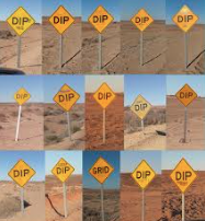
It was a long day on bumpy roads for us, but toward the end, keeping an eye out for the next ‘DIP’ sign made the time go quickly. A vandal with a good sense of humour had added a word to each DIP sign – and there were many. The signs included..Slippery DIP, Cheese DIP, Skinny DIP, Lucky DIP, DIPtheria and many more..

Screen Shot 2019-10-08 at 8.29.33 pm

It was much harder work than travelling on the tar road to the south, but definitely worth it for the experience and scenery!!


Every town has a story…

10th September

Yesterday, instead of sticking to the main road south to get to the Flinders Ranges, we decided that we’d take a few days and detour to the north.

Day one was unexpectedly interesting, as we passed through Woomera, Roxby Downs and Andamooka – each town with a completely different history.

Woomera

Just off the main road, this town was a base for weapon testing and rocket launching from the 1947. The town was restricted to the public until 1982. Now, they have an outdoor museum you can visit, with actual missiles and rockets and replicas of those that were used and tested decades ago.


They also have a really cool little museum, with relics and artefacts from the early days. There was some interesting information about living in the town when it was still restricted and the controversy of the testing at the time, about Len Beadel, who was responsible for constructing most of the roads in the area, and about the Detention Centre that was here in the 1990s.


The town seems so out of place, in the middle of the desert, with its neatly laid streets and kerb and gutter. And it still looks like the 70s or 80s, with the old cinema and the style of cafes and furniture in both the cinema and information centre.

Woomera today, is still administered by the Australian Defence Force and the Woomera prohibited area, testing range extends for 127000 square kilometres in the surrounding area. Fascinating!

Andamooka

This little town, like Copper Pedy, was established for Opal Mining. It remains today, much as you would expect it would have looked back in the mid 1900s when mining was at its peak.

The hub of the town is the Post Office, with a house made of bottles out the front and a really quirky little museum underneath. I loved the pictures and stories of the characters in the town in the early days.

Along the main street, there is a strip of old mining houses dug into the ground, the same as they do in Cooper Pedy, to give relief from the summer heat. However, these houses are still in their original condition and full of original furniture and cooking utensils etc. they are not locked up and you are free to roam through. It amazes me that you can have something like this open to the public and it hasn’t all been stolen.

And there’s a collection of old mining vehicles at the other end of town


Roxy Downs

I don’t have any photos of Roxby Downs, but this town has it’s own history, built as a hub for the controversial Olympic Dam Mine. Although it is in the middle of the desert, it is a typical mining town , with all the modern facilities and amenities that you’d expect of a town close to the city.

IMG_20190910_103138481


Lake Hart – Salt Lake

9th September

What a great overnight stop this was – and a free camp too!!


The lake itself was pretty cool and we were able to walk out on it.  It looks just like snow and you could still see the remains of the jetty from before it dried out.


For me, the best part was the setting, beside the red sand dunes and train line.


The perfect place to film a song – number #9 in the Cam&Matt in the Van Challenge


We saw about 4 or 5 trains go by, a few up close and we saw the Ghan go by later in the evening from up at camp.


And the the sunset was beautiful!


All topped off by star gazing by the fire.

IMG_20190908_184517259


Cooper Pedy

8th September

Coober Pedy is a town in South Australia, which was originally established for Opal mining about 100 years ago. It is in a very desolate area – not a scrap of green to be seen. But it is a fascinating little town!!

IMG_20190907_103940701


As you approach the town, the most notable thing is that there are mounds of dirt lying around everywhere, a stark contrast from the otherwise completely flat landscape. This is where they’ve dug to look for opals.


The roadsigns warn of the danger 🙂


There is some really cool, unique mining machinery throughout the town.


We also did a great mine tour at one of the few mines still in operation. Very cool to explore all the underground tunnels and see the equipment they use. We finished off with a bit of ‘noodling’ for Opals.


Many people in Cooper Pedy live in underground homes to avoid scorching summertime temperatures. Most of the churches are also built underground.


And about 20km out of town you can drive along the Dog Fence – the longest continual structure in the world. It is over 5000km long and was built to keep the dingoes from coming into the south. The landscape is very desolate here – almost like a lunar landscape.


And then , just a few kilometres further along, are the Breakaways – beautiful coloured rock formations, rising out of the desert. Just stunning!!


Perfect backdrop for a song for the “Cam&Matt in the Van” Challenge


And to top off our time in this quirky little town, we went to the ‘drive-in’ on our last night. Not many left in the whole country – the kids loved it!

Red Centre Recap

We have had a great couple of weeks exploring this part of the country…

IMG_0322

From Alice Springs, to the West MacDonnell Ranges. Along the Mereenie Loop Road to Kings Canyon. And finishing off with Uluru-Kata Tjuta National Park.

We have seen some beautiful and amazingly varied scenery. The geological history of the area is fascinating!!

We loved the gorges and great hiking through the West MacDonnell’s…and camping on the banks of the Finke River. Lots of flies though!! And would love to come back another time after a good rainy season when it’s not so dry.


We were surprised by King’s Canyon and the stunning weathered beehive sandstone domes, similar to those that the Bungle Bungles are famous for.


The Olgas, although probably overshadowed by their neighbour Uluru, are definitely worth exploring. Huge rock domes, some of which are more than 100 meters taller than Uluru – the tallest 546m. Interesting that they are made of conglomerate rock.


And of course, Uluru, which needs no explanation. Pretty impressive to have a rock that is 2.5 times the height of the Sydney Harbour Bridge, rising out of the middle of the desert. Loved the changing colours throughout the day and particularly at sunrise and sunset. From a distance it looks like a big smooth rock, but exploring up close you find lots of valleys, plunge pools and caves. The climb was the highlight for the boys!!


Uluru

5th September

Of course, no trip to the Red Centre is complete without visiting Uluru

– and it did not disappoint!!

IMG_20190905_070523078


It is different from every angle – and in different light and different times of the day.

Sometimes you can see all the ridges and at other times it looks almost completely smooth – and the colour changes from a dull brown, through every shade, to brilliant red/orange.

From the sunrise angle…


Sunsets..


It also looks different up close, depending on the perspective…


The Climb

You begin with a climb up the steepest part, using the chains to assist.


Once at the top, rather than levelling out, the rock becomes a series of steep ups and downs all the way to the peak.


It’s really hard to try and convey how steep it is, and you don’t actually realise till you’re doing it


It was such a challenging climb, both in terms of the actual physical effort required, but also dealing with my fear of edges. But so worth it!


The views from the top are superb…particularly looking back toward the Olgas.

IMG_9820


The Base Walk

The 10km walk around the base gives a completely different perspective.

Some parts are lush and green, tall gorges and deep holes and ridges worn from the flow of water.


Other parts are dry harsh.


And some beautiful Aboriginal Art in some of the caves.


All in all, we had a wonderful 3 days exploring this magnificent natural landmark.

IMG_20190903_183523441

The Olgas

2nd September

Kata Tjuta (The Olgas) are stunning rock domes, about 40km from Uluru.

IMG_20190902_174659381_HDR


Like Uluru, they just rise out of the plains, except there are 36 individual domes.

IMG_9867


You don’t realise how big they are until you get in and walk amongst them.


I found it fascinating that the domes are actually made up of conglomerate rock.


We did the ‘Valley of the Winds’ walk, which had stunning views in and around the domes.


At Walpa Gorge, you walk between two of the tallest domes.


It’s hard to believe that they are over 100m taller than Uluru.

You can see how small Matt looks in the photo on the right!!


King’s Canyon

31st August

We really enjoyed King’s Canyon!

You can take a short walk along the bottom of the gorge and look up at the gorge walls.


But the Rim walk was the highlight, with great views of the steep, red canyon walls and walking amongst the bee-hive, weather sandstone domes.

It’s a steep climb up, but as soon as you’re up high you start to get the views.


First you walk in amongst the huge weathered sandstone, beehive domes.


Then it opens up and you can see the steep canyon walls

IMG_20190830_104336221_HDR


You can climb up and get amazing views looking all the way down the gorge.


Then you walk over the top of some beehive domes..


And climb down into the ‘Garden of Eden’ – a pretty valley with plant life surrounded by beehive domes – before continuing around along the south rim.


We were really surprised by how much was up on the rim – such a rewarding walk!!

Back at camp, there was a nice atmosphere in the evenings, as a crowd gathers at the lookout to have sundowners.


Intermission – Lack of internet reception

Hi to anyone who is following our blog…

Sorry, I’m running a few weeks behind. We have been struggling with lack of internet to post and/or lack of power to charge my computer…the challenges of travelling in the Outback!!

I have heaps of pics to post of the Red Centre – Kings Canyon, The Olga’s and of course Uluru.

The past week we have seen some fascinating towns and scenery in Outback South Australia.

Lots to come…will be back online again soon…

Mereenie Loop Road

29th August

Leaving the West MacDonnell ranges, we opted to take the unsealed Mereenie Loop Road to Kings Canyon, rather than backtrack to Alice Springs.

Just before the turnoff to the road we went up over Talylor’s Pass where you get fabulous views! The mainly flat plains are broken by what appears to be a mountain range, but is actually a crater from a meteorite that hit millions years of years ago.


The road itself is typical – red dirt, rocky and corrugated. Luckily the road had been recently graded, so although very dusty and corrugated, not as notoriously bad as usual. We just lowered the tyre pressure and took it slow.


The scenery though was quite nice, with rocky outcrops lining the road for most of the way, before heading into flat scrub – with plenty of shredded tyres and a few abandoned cars along the way.


The highlight was overnighting at this free camp at a lookout about 30km before Kings Canyon.

IMG_20190828_181549006_HDR


The views out over the valley, looking toward the King’s Canyon were stunning!!


As the sun set, the shadows highlighted the triangular shape of the ranges below.


We had a lovely afternoon, having sundowners with some fellow travellers and later a few more drinks around the fire.


This morning on our drive into King’s Canyon we saw our first dingos in the wild, just casually wandering along the road.